
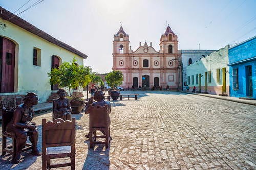
Historic Centre of Camagüey
One of the first seven villages founded by the Spaniards in Cuba, Camagüey played a prominent role as the urban centre of an inland territory dedicated to cattle breeding and the sugar industry. Settled in its current location in 1528, the town developed on the basis of an irregular urban pattern that contains a system of large and minor squares, serpentine streets, alleys and irregular urban blocks, highly exceptional for Latin American colonial towns located in plain territories. The 54 ha Historic Centre of Camagüey constitutes an exceptional example of a traditional urban settlement relatively isolated from main trade routes. The Spanish colonizers followed medieval European influences in terms of urban layout and traditional construction techniques brought to the Americas by their masons and construction masters. The property reflects the influence of numerous styles through the ages: neoclassical, eclectic, Art Deco, Neo-colonial as well as some Art Nouveau and rationalism.
One of the first seven villages founded by the Spaniards in Cuba, Camagüey played a prominent role as the urban centre of an inland territory dedicated to cattle breeding and the sugar industry. Settled in its current location in 1528, the town developed on the basis of an irregular urban pattern that contains a system of large and minor squares, serpentine streets, alleys and irregular urban blocks, highly exceptional for Latin American colonial towns located in plain territories. The 54 ha Historic Centre of Camagüey constitutes an exceptional example of a traditional urban settlement relatively isolated from main trade routes. The Spanish colonizers followed medieval European influences in terms of urban layout and traditional construction techniques brought to the Americas by their masons and construction masters. The property reflects the influence of numerous styles through the ages: neoclassical, eclectic, Art Deco, Neo-colonial as well as some Art Nouveau and rationalism.


Outstanding Universal Value
One of the first seven villages founded by the Spaniards in Cuba, Camagüey played a prominent role as the urban centre of an inland territory dedicated to cattle breeding and the sugar industry. Once settled in its current location in 1528, the town developed on the basis on an irregular urban pattern that contains a system of squares, minor squares, serpentine streets, alleys and irregular urban blocks, highly exceptional for Latin American colonial towns located in plain territories. Religious buildings, associated with the main squares, constitute a system of landmarks in the urban fabric, characterized by its homogeneity. Architectural values are associated with typical domestic architectural typologies and the use of consistent construction materials and techniques, especially the extended use of earthen components, which reveal influences from Andalusia. The use of truncated pilasters at the entrance gates and of clay vessels for water storage are features that identify Camagüey’s domestic architecture. The historic centre continues to act as the city core and the place for social and cultural activities, which reflect a rich intangible heritage.
Criterion (iv): The Historic Centre of Camagüey constitutes an outstanding urban architectural type in Latin America, featured by its irregular urban layout that produced an unusual system of squares, minor squares, serpentine streets, alleys, urban blocks and plots system. Monumental and domestic architecture form a homogeneous urban fabric where it is possible to find architectural expressions corresponding to different periods of the evolution of the town.
Criterion (v): The Historic Centre of Camagüey constitutes an exceptional example of a traditional urban settlement relatively isolated from main trade routes, where the Spanish colonizers were subject to European medieval urban influences in the urban layout and to traditional construction techniques brought to the Americas by the first masons and construction masters.
The nominated property is of adequate size and contains all the necessary material components to guarantee the integrity of the historic centre. The persistence of the original urban layout, of the architectural types and materials, of the traditional craftsmanship and of uses and spirit allows the historic centre to meet the required conditions of authenticity.
The legal protection and the management system and instruments have proved to be adequate for ensuring the proper conservation of the nominated area and its buffer zone.
Historical Description
Santa María del Puerto del Príncipe (now Camagüey) is one of the seven villages founded by the Spaniards in the 16th century in Cuba. It was one of two villages settled on the north coast of the island, against the prevailing preference for the south coast. The first settlement may have been founded in 1514 or 1515. Before 1528, the village was moved twice but then was definitively settled in its current location. Even though an original plan has not been found, it is known that the village had a square shape and buildings were constructed in timber and palm tree.
On 15 December 1616, the village was destroyed by fire. The town was then reconstructed but, from the beginning of 17th century, it became the target of pirate attack and was constantly threatened by tropical storms. Although water was supplied from the neighbouring rivers, the population developed water reservoirs and water was stored in large jars or vessels, similar to those used in Andalusia. This gave the town the name of "City of the Earthen Jars" (Tinajones). These containers, as well as brick and tiles, were manufactured in the village from 1620. At the same time, the Royal Road of Cuba was constructed, connecting the village with other Cuban towns, such as Havana, Sancti Spiritus, Santiago and Bayamo.
After the corsair Morgan´s attack in 1668, the centre of the village was reconstructed in its final location. The Older Square was perfected into an orthogonal layout, contrasting with the irregular pattern of the rest of the village. The definitive settlement of the village relates to the end of the 17th century. New churches were then constructed and neighbourhoods gathered around religious buildings. The construction of religious complexes and more solid civic buildings, from the end of 17th century to the beginning of 18th century, shows that the town was accumulating capital, following the development of the sugar industry. The urban structure was consolidated into the image that it still portrays.
The sugar industry led to economic growth. By 1750, Puerto Príncipe had become a prosperous town with some nine churches. The domestic architecture of that time has become one of the main examples of colonial architecture. In the second half of the century, architectural codes were consolidated and prevailed over most of the 19th century. Eaves, truncated pilasters framing main entrance doors and lathed balustrades covering windows became typical in urban residences - featuring a town which was geographically and culturally isolated from both the capital and abroad.
By 1774, Puerto Príncipe had nearly 18,000 inhabitants, thus becoming the second town in Cuba. The position of the town determined the location of the Royal Audience, which was one of the most important institutions in Latin America. The removal of the Royal Audience from Santo Domingo to Puerto Príncipe favoured the arrival of illustrious men who contributed to the improvement and enhancement of the town's cultural life during the 19th century. The prevailing function of the village during the 18th century was religious, as is apparent in the churchhousing relation. The Old Square became the scene for Catholic processions and festivities, while incorporating some African elements introduced by the slaves.
At the beginning of the 19th century, the village was divided into six administrative units, with the churches at their core. In 1856, ordinances were issued to regulate the urban layout. There was concern at the previous spontaneous layout and new construction standards introduced neoclassical elements, causing a rupture with tradition. After 1881, development peaked again; modern sugar refineries were constructed and the town benefited with construction of new buildings responding to the functional and stylistic requirements of the time. Puerto Príncipe echoed Europe. During the first decades of the 20th century, streets were paved in stone while fresh architectural styles were introduced downtown. In 1978, the historic centre of Camagüey was declared a National Monument.
Source: UNESCO/CLT/WHC
Share Thread Share your opinion interested
Artikel Menarik Lainnya
 City of Verona
The historic city of Verona was founded in the 1st century B.C. It particularly flo
City of Verona
City of VeronaThe historic city of Verona was founded in the 1st century B.C. It particularly flo Archaeological Area of Agrigento
Founded as a Greek colony in the 6th century B.C., Agrigento beca
Archaeological Area of Agrigento
Archaeological Area of AgrigentoFounded as a Greek colony in the 6th century B.C., Agrigento beca Historic Centre of Naples
From the Neapolis founded by Greek settlers in 470 B.C. to the city of t
Historic Centre of Naples
Historic Centre of NaplesFrom the Neapolis founded by Greek settlers in 470 B.C. to the city of t Garajonay National Park
Laurel forest covers some 70% of this park, situated in the middle of the
Garajonay National Park
Garajonay National ParkLaurel forest covers some 70% of this park, situated in the middle of the  Genoa: Le Strade Nuove and the system of the Palazzi dei Rolli
The Strade Nuove and the system of
Genoa: Le Strade Nuove and the system of the Palazzi dei Rolli
Genoa: Le Strade Nuove and the system of the Palazzi dei RolliThe Strade Nuove and the system of  Mantua and Sabbioneta
Mantua and Sabbioneta, in the Po valley, in the north of Italy, represent
Mantua and Sabbioneta
Mantua and Sabbioneta
Mantua and Sabbioneta, in the Po valley, in the north of Italy, represent
EmoticonEmoticon