
Te Wahipounamu – South West New Zealand
The landscape in this park, situated in south-west New Zealand, has been shaped by successive glaciations into fjords, rocky coasts, towering cliffs, lakes and waterfalls. Two-thirds of the park is covered with southern beech and podocarps, some of which are over 800 years old. The kea, the only alpine parrot in the world, lives in the park, as does the rare and endangered takahe, a large flightless bird.
The landscape in this park, situated in south-west New Zealand, has been shaped by successive glaciations into fjords, rocky coasts, towering cliffs, lakes and waterfalls. Two-thirds of the park is covered with southern beech and podocarps, some of which are over 800 years old. The kea, the only alpine parrot in the world, lives in the park, as does the rare and endangered takahe, a large flightless bird.

Outstanding Universal Value
Brief synthesis
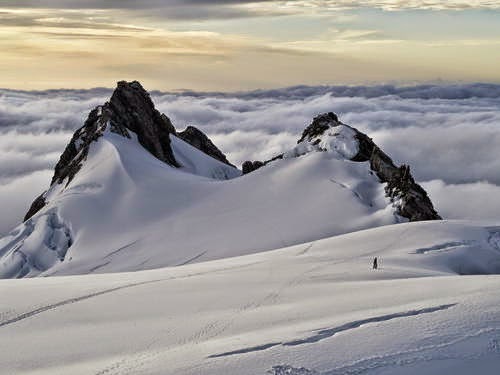
Located in the south-west corner of New Zealand’s’ South Island, Te Wähipounamu – South West New Zealand covers 10% of New Zeland’s landmass (2.6 million hectares) and is spread over a 450km strip extending inland 40 - 90km from the Tasman Sea. The property exhibits many classic examples of the tectonic, climatic, and glacial processes that have shaped the earth. The great Alpine Fault divides the region and marks the contact zone of the Indo-Australian and Pacific continental plates making it one of only three segments of the world’s major plate boundaries on land. Collision between the two tectonic plates constructs the main mountain range, known as the Southern Alps/Kä Tiritiri o te Moana, which rise to nearly 4 000m altitude within a mere 30km from the sea.
Overwhelmingly a mountainous wilderness, including significant piedmont surfaces in the north-west glaciation, both historic and modern, is a dominant landscape feature. Spectacular landforms include: the 15 fiords which deeply indent the Fiordland coastline; a sequence of 13 forested marine terraces progressively uplifted more than 1000m along the Waitutu coastline over the past million years; a series of large lake-filled glacial troughs along the south-eastern margin; the Franz Josef and Fox Glaciers which descend into temperate rainforest; and spectacular moraines of ultramafic rock extending to the Tasman coastline.
As the largest and least modified area of New Zealand's natural ecosystems, the flora and fauna has become the world’s best intact modern representation of the ancient biota of Gondwana. The distribution of these plants and animals is inextricably linked to the dynamic nature of the physical processes at work in the property. The region contains outstanding examples of plant succession after glaciation, with sequences along altitudinal (sea level to permanent snowline), latitudinal (wet west to the dry east), and chronological gradients (fresh post-glacial surfaces to old Pleistocene moraines).
It is the combination of geological and climatic processes, the resultant landforms, the unique biota displaying evolutionary adaptation over a diverse range of climatic and altitudinal gradients, all in a relatively pristine state, that give Te Wähipounamu – South West New Zealand its exceptional and outstanding natural characteristics.
Criterion (vii): Te Wähipounamu - South West New Zealand contains many of the natural features which contribute to New Zealand's international reputation for superlative landscapes: its highest mountains, longest glaciers, tallest forests, wildest rivers and gorges, most rugged coastlines and deepest fiords and lakes, as well as the remnant of an extinct volcano in Solander Island. The temperate rainforests of the property are unmatched in their composition, extent and intactness by any such forests anywhere in the world.
From the vast wilderness of Fiordland in the south to the spectacular upthrust of the Southern Alps in the north, the landscapes are world class for the sheer excellence of their scenic beauty. It is an area of magnificent primeval vistas: snow-capped mountains, glaciers, forests, tussock grasslands, lakes, rivers, wetlands and over 1000km of wilderness coastline. Only traces of human influence are evident and then mainly in peripheral areas.
Criterion (viii): Te Wähipounamu - South West New Zealand is considered to be the best modern example of the primitive taxa of Gondwanaland seen in modern ecosystems – and as such the property is of global significance. The progressive break-up of the southern super-continent of Gondwanaland is considered one of the most important events in the earth’s evolutionary history. New Zealand’s separation before the appearance of marsupials and other mammals, and its long isolation since, were key factors enabling the survival of the ancient Gondwanan biota on the islands of New Zealand to a greater degree than elsewhere. The living representatives of this ancient biota include flightless kiwis, carnivorous land snails, 14 species of podocarp and genera or beech.
The South West is also an outstanding example of the impact of the Pleistocene epoch of earth history. Ice-carved landforms created by these “Ice Age” glaciers dominate the mountain lands, and are especially well-preserved in the harder, plutonic igneous rocks of Fiordland. Glacier-cut fiords, lakes, deep U-shaped valleys, hanging valleys, cirques, and ice-shorn spurs are graphic illustrations of the powerful influence of these glaciers on the landscape. Depositional landforms of Pleistocene glacial origin are also important, especially in Westland, west of the Alpine Fault. Chronological sequences of outwash gravels, and moraine ridges in elegant curves and loops, outline the shapes of both former piedmont glaciers and Holocene "post-glacial" valley glaciers.
Criterion (ix): A continuum of largely unmodified habitats, the property exhibits a high degree of geodiversity and biodiversity. Fresh-water, temperate rainforest and alpine ecosystems are all outstandingly well represented over an extensive array of landforms and across wide climatic and altitudinal gradients. Notable examples of on-going biological processes can be found in the large expanses of temperate rainforest, the plant succession after glacial retreat, soil/plant chronosequences on beach ridges, plant succession on alluvial terraces, vegetation gradients around the margins of glacial lakes and ecotypic differentiation of plants on ultramafic soils. The extensive and little modified freshwater habitats, the impressive diversity of alpine ecosystems, extensive alpine plant endemism, and on-going evolution associated with long-standing geographical isolation of animal populations, like the kiwi taxa of South-Westland, are further examples of on-going biological evolution.
While there is little permanent physical evidence of past human interaction with the natural environment, tangata whenua (the indigenous people who have customary authority in a place) have long associations with the area which was significant to them for natural resources, particularly pounamu (nephrite). European associations are more recent and initially based on natural resource exploitation. The predominant human uses today are associated with sustainable tourism.
Criterion (x): The habitats of Te Wähipounamu contain an extensive range of New Zealand’s unusual endemic fauna, a fauna which reflects its long evolutionary isolation and absence of mammalian predators. The property contains the entire wild population of the rare and endangered takahë (Notornis mantelli), the entire population of the South Island subspecies of brown kiwi (Apteryx australis), New Zealands rarest Kiwi, the rowi (Apteryx rowi), the only significant remaining populations of the seriously declining mohua / yellowhead (Mohoua ochrocephala), the only large populations remaining of käkä and käkäriki / yellow-crowned parakeet, the only remaining population of pateke / Fiordland brown teal in the South Island.
The world's rarest and heaviest parrot, käkäpö (Strigops habroptilus) survived in Fiordland until the early 1980s. It is now thought to be extinct on the mainland and its survival depends on careful management of a limited number of offshore island populations.
Integrity
Te Wähipounamu encompasses many complete ‘mountains-to-the-sea’ or ‘mountains-to-inland basins’ landscape sequences. These landscapes cover the full range of erosion and deposition landforms of Pleistocene and modern glacial origin. The 2.6 million hectare property represents the 10 percent of New Zealand that is least disturbed or modified by human settlement, and is largely in its natural state giving it a high degree of integrity. The property boundaries encompass all the values of the property which comprises a nearly contiguous network of reserved land covering much of the south-west of the South Island. The boundaries are closely and realistically aligned with the main features of the area. The property includes four national parks (Fiordland, Mount Aspiring, Mount Cook and Westland) covering 1,725,437 ha, two nature reserves, three scientific reserves, 13 scenic reserves, four wildlife management reserves, five ecological areas, conservation areas and one private reserve (20 ha). Bordered by other protected public conservation land the property has an effective buffer zone providing further protection for the natural values.
The property contains nearly 2 million hectares of temperate rainforest on an extraordinary range of landforms and soils-including altitudinal, latitudinal, west-to east rainfall gradients, and age sequences associated with glacial retreat, prograding coastlines and marine terraces uplifted progressively over the last million years. In particular, the rainforest contains the best examples in the Southern Hemisphere of one of the most ancient groups of gymnosperms, the Podocarpaceae, which range from the densely-packed 50m-high rimus of the South Westland terraces to the world’s smallest conifer, the prostrate pygmy pine.
The relatively recent introductions of alien browsing mammals and predators, such as rodents and mustelids, have resulted in localised extinctions, range reductions, and significant declines in abundance of some indigenous biota. These threats will remain, but with ongoing intervention can be managed and should not impact significantly on the integrity of the area. There is some evidence of the effects of global warming on the permanent icefields and glaciers in the region.
The international profile of the area as a visitor destination places pressure on some of the main tourist attractions within the wider site. These pressures are being managed to provide visitor access but only where the conservation values at these sites are protected.
Protection and management requirements
A comprehensive array of statutes and regulations protect the property, the most important being the National Parks Act 1980 and the Conservation Act 1987. These two pieces of legislation along with the Reserves Act 1977 are the principal means of ensuring legal protection for the property. The land encompassed by the boundaries of the property, with one small exception, is Crown (Government and the people of New Zealand) owned and it is administered by the Department of Conservation. The property is a reformulation of two previous property inscribed on the World Heritage List in 1986; Fiordland National Park and Westlands / Mt Cook National Park. This property adds 1.2 million ha of the intervening land, almost doubling the size of the area inscribed in 1986 and including almost 70% of the area under national park status, and greatly adding to the overall universal value, wilderness quality and integrity of the property.
The Department of Conservation has a legislative mandate for the preservation and protection of natural and historic resources for the purpose of maintaining their intrinsic values, providing for their appreciation and recreational enjoyment by the public, and safeguarding the options of future generations.
The Department of Conservation is obligated through its legislation to give effect to the principles of the Treaty of Waitangi. In practice this implies a partnership agreement with tangata whenua that have manawhenua (prestige, authority over the land) over the area. This involves an annual business planning process with the Ngäi Tahu iwi (the overarching tribal authority for tangata whenua). This process gives Ngäi Tahu the opportunity to engage in and contribute to the operational management of the property.
The particularly high natural values of the property, along with the World Heritage status, mean that this area is a priority area for ongoing management. The Area covers four separate Conservancies, although they all report to one Manager. The Department’s organisational structure therefore also provides for integrated management of the area.
There is no single management strategy for the area, although under the National Parks Act, each national park is required to have a national park management plan and there are also a number of conservancy conservation strategies that acknowledge the values of the regions comprising the large site, as well as the property’s World Heritage status. Together these planning documents set strategic directions for the integrated management of this property. These are statutory documents formulated through a public consultation process. The national park management plans are prepared by the Department of Conservation (the administering authority for all national parks in NZ) and approved by the New Zealand Conservation Authority, in accordance with the General Policy for National Parks (a policy document that guides the implementation of the National Parks Act, also prepared and administered by the Department of Conservation).
The principal uses of the property are nature conservation, nature based recreation and tourism and sustainable small-scale natural resource utilisation. Impacts from tourism at key sites and introduced species are being addressed by management actions and continue to be a concern. Traditional use of vegetation by native Maori people, fishing for whitebait, recreational hunting and short-term pastoral leases are closely regulated and do not result in significant impacts.
Invasive species are the biggest impact on the property, despite their impacts being restricted to small areas of the property. Population increases of red deer as well as impacts from other browsing mammals such as wapiti, fallow deer, goat, chamois and tahr have caused severe damage in some parts of the property, in particular threatening the integrity of the forest and alpine ecosystems. Commercial hunting activities have assisted in reducing numbers and impacts from these species. Australian brush-tailed possum, rabbits, mustelids and rodents also impact habitats and indigenous birds. The Department of Conservation has control programmes in place and National Parks general policy seeks to eradicate new incursions and eradicate (where possible) or reduce the range of existing invasive species.
Long Description
Te Wahipounamu comprises the least-disturbed tenth of New Zealand's land mass, with some 2 million hectares of temperate rainforest, 450 km of alpine communities, and a distinctive fauna. It contains the best modern representation of the ancient flora and fauna of Gondwanaland, including Podocarpus species, genera of beech, flightless kiwis, 'bush' moas and carnivorous Powelliphanta land snails.
The overwhelming mountainous character of the area results from tectonic movement between the Pacific plate and the Indo-Australian plate over the last 5 million years. High local relief is the result of deep glacial excavation. Glaciers are an important feature of the nominated area, especially in the vicinity of Westland and Mount Cook national parks. There have also been substantial post-glacial changes, especially marked in South Westland and the Southern Alps. Erosion is rapid, especially west of the Main Divide. Intense gullying, serrated ridges, and major and minor rock falls are characteristic of this zone. However, glacial landforms are almost entirely intact in Fiordland.
The vegetation is notable both in national and international terms for its diversity and essentially pristine condition. A floristically rich alpine vegetation of shrubs, tussocks and herbs extends around the summits of the mountains, from about 1,000 m to the permanent snowline. At warmer lower altitudes, the rainforest is dominated by dense stands of tall podocarps. The wetter, milder west is characterized by luxuriant rainforest and wetlands; the drier, more continental east has more open forest, shrublands and tussock grasslands. The most extensive and least modified natural freshwater wetlands in New Zealand are found in this area. Sizeable open wetlands, including high-fertility swamps and low-fertility peat bogs, are a particular feature of the south Westland coastal plain.
The best-known vegetation chronosequences are those on glacial landforms where the ages of outwash, terrace and higher piedmont surfaces are known. The most impressive landform chronosequence is the flights of marine terraces in southern Fiordland. As the least-modified region on mainland New Zealand, the south-west is the core habitat for many indigenous animals, including a number of primitive taxa, and contains the largest and most significant populations of forest birds in the country, most of which are endemic to New Zealand. A few mountain valleys in Fiordland harbour the total wild population (about 170 birds) of the takahe, a large flightless rail believed extinct until 'rediscovered' in 1948 and which is recognized as endangered. Most of New Zealand's fur seals are found along the south-west coast. Virtually wiped out by sealing in the early 1800s, they currently number about 50,000.
A Maori association with the area falls into three broad categories: mythological, traditional history and ethnological. All these values are contained within the tradition of the Ngai Tahu tribe, whose ancestral territories cover all except the extreme northern parts of South Island.
Source: UNESCO/CLT/WHC
Historical Description
Proposed for inscription on the Unesco World Heritage List in 1990. A major preservation initiative was the reservation for national park purposes of 950,OOOha of Fiordland in 1904. The name was subsequently changed to Fiordland National Park when it was gazetted under national parks legislation in 1955. Mount Cook and Westland national parks were gazetted in 1953 and 1960, respectively, and Mount Aspiring National Park in 1964. Mount Aspiring National Park almost doubled in size by the mid-1970s, and 24,285ha was added in 1989. The
upper Karangarua Valley was added to Westland National Park in 1983. Much of the land not included within national park has been managed as State forest land under the Forests Act, Crown land under the Land Act or as reserves under the Reserves Act.
Source: UNESCO/CLT/WHC
Share Thread Share your opinion interested
EmoticonEmoticon