
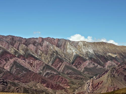
Quebrada de Humahuaca
Quebrada de Humahuaca follows the line of a major cultural route, the Camino Inca, along the spectacular valley of the Rio Grande, from its source in the cold high desert plateau of the High Andean lands to its confluence with the Rio Leone some 150 km to the south. The valley shows substantial evidence of its use as a major trade route over the past 10,000 years. It features visible traces of prehistoric hunter-gatherer communities, of the Inca Empire (15th to 16th centuries) and of the fight for independence in the 19th and 20th centuries.
Quebrada de Humahuaca follows the line of a major cultural route, the Camino Inca, along the spectacular valley of the Rio Grande, from its source in the cold high desert plateau of the High Andean lands to its confluence with the Rio Leone some 150 km to the south. The valley shows substantial evidence of its use as a major trade route over the past 10,000 years. It features visible traces of prehistoric hunter-gatherer communities, of the Inca Empire (15th to 16th centuries) and of the fight for independence in the 19th and 20th centuries.


Outstanding Universal Value
Brief synthesis
Quebrada de Humahuaca, located in the Province of Jujuy, is a narrow and arid mountainous valley, flanked by the high plateau of the Puna and the eastern wooded areas. It is located in the north-westernmost portion of the Republic of Argentina and follows the line of a major cultural route, the Camino Inca, along the spectacular valley of the Rio Grande, from its source in the cold high desert plateau of the High Andean lands to its confluence with the Rio León, forming a 155-kilometre long, north-south striking natural corridor, where the Grande de Jujuy river flows.
It is a highly representative example of the south Andean valleys, with an exceptional system of communication routes and economic, social and cultural coordination. This is the most important physical linkage between the high Andean lands and the extensive temperate plains in south-eastern South America. Its impressive natural environment is kept almost intact, with hundreds of archaeological and architectural sites that bear witness to its long and rich history. The valley shows substantial evidence of its use as a major trade route over the past 10,000 years. Scattered along the valley are extensive remains of successive settlements whose inhabitants created and used these linear routes. They include prehistoric hunter/gatherer and early farming communities (9000 BC to AD 400), large structured agricultural societies (AD 400-900), flourishing pre-Hispanic towns and villages (900-1430/80), the Incan empire (1430/80-1535), Spanish towns, villages and churches (153/93-1810), and traces of Republican struggles for independence (1810-20th century). Of particular note are the extensive remains of stone-walled agricultural terrace fields at Coctaca, thought to have originated around 1,500 years ago and still in use today; these are associated with a string of fortified towns known as pucaras . The field system and the pucaras together make a dramatic impact on the landscape and one that is unrivalled in South America. The valley also displays several churches and chapels and a vibrant vernacular architectural tradition.
The current population, on its part, keeps its traditions in an outstanding cultural landscape. Thus, Quebrada de Humahuaca is an extremely complex heritage system characterised by elements of various kinds inserted in a stunning, impressive and colourful landscape. The interaction between the geo-ecological system and the successive societies and cultures that have occupied it for the last 10,000 years shows space-time continuity that is hard to find in other areas. Separated from the ensemble, only a few properties can be considered unique and outstanding. However, the combination of natural and cultural elements has given rise to a site that is beyond comparison in every sense.
Criterion (ii): The Quebrada de Humahuaca valley has been used over the past 10,000 years as a crucial passage for the transport of people and ideas from the high Andean lands to the plains.
Criteria (iv) and (v): The Quebrada de Humahuaca valley reflects the way its strategic position has engendered settlement, agriculture and trade. Its distinctive pre-Hispanic and pre-Incan settlements, as a group with their associated field systems, form a dramatic addition to the landscape and one that can certainly be called outstanding.
Integrity
The attributes that sustain the Outstanding Universal Value of Quebrada de Humahuaca are included within the boundaries of the inscribed property and the buffer zone, which ensures the complete representation of its significance as an evolving and dynamic landscape. Quebrada de Humahuaca is a combination of different aspects of settlements and transport routes which together make up the cultural route and the cultural landscape. Overall the valley still retains a high degree of integrity but this is made up of a combination of discrete factors, each of which need to be assessed individually. The archaeological sites are well preserved as well as the conservation of construction techniques and the features of Hispanic churches. Most of the remains of the later abandoned settlements are likewise reasonably intact and have a high integrity. There is one exceptions and that is the Pucara of Tilcara which was partially reconstructed in the 1940s and thus now has low integrity. Many of the field systems associated with the pucaras are still in use and thus have integrity as part of a continuing agricultural system. The vulnerability of this site arises from the weakness of public policies and laws relating to the territorial planning, which may threaten the integrity of this property.
Authenticity
The attributes showing of the property preserve their authenticity, keeping its technology, use and traditions, while incorporating new elements without affecting its harmonious relation to the environment. At the same time, it continues fulfilling its millenary function as a space for communication, exchange and human settlement. The authenticity of this property, as an evolving cultural landscape, is reflected on the balance between the local uses and traditions and the introduction of modern materials and techniques. The Spanish Churches still retain their overall form and particular construction techniques, although a few seem to have been over restored. The cores of the main settlements still hold onto their distinctive low-rise form and traditional spatial planning but around the margins show diminishing authenticity in response to development pressures. On the other hand, there is evidence that the use of introduced modern materials is being countered by an increasing interest in the use of traditional local materials and techniques as a means of asserting identity.
Protection and management requirements
The legal framework of Quebrada de Humahuaca comprises the Provincial Law on Protected Landscapes N°5206/00 and its decree 789/004 various regulations for the protection of specific properties, as well as municipal laws. The National Constitution of 1994 provides the overarching framework for the protection of both the cultural and natural heritage, through establishing the right to protection in order to enjoy a healthy and balanced environment. Other relevant Acts include the National Decree N°1012/00 which declared as National Historical Monuments the archaeological deposits of Coctaca, Los Amarillos, el Pucara de Tilcara and La Huerta; the National Tourism Secretariat Resolution N°242(1993), whereby Quebrada de Humahuaca and its integral villages were declared of National Interest; the National Decree of 1975 whereby the two villages of Purmamarca and Humahuaca were declared Historical Places; the National Decree of 1941 which protected the six key chapels and churches as Historical Monuments; the National Law N° 25743/03which protected archaeological and paleontological deposits as assets of scientific interest. Further Provincial Laws protect folklore and craftsmanship as well as heritage of provincial importance. Specifically a provincial Decree of 2000 gives high priority to pursuing the inscription of Quebrada as a World Heritage Site and a Resolution shaped the composition of the Technical support Team for the proposed World Heritage Site. Overall therefore, Quebrada is well protected by both general and specific legislation designed to protect its discrete cultural heritage and there is also a legal framework for the coordinating management structure.
The management plan of Quebrada de Humahuaca is the tool for the protection and preservation of its values, which aims at achieving a comprehensive administration, as well as solving authority, jurisdiction and dominion problems that may arise in a property characterised by a great extent, complexity and dynamism. Quebrada de Humahuaca is envisioned as a site with a strengthened identity, territorially planned, and protected against natural dangers, with legally supported production diversity, a balanced environment and a better quality of life for its inhabitants.
Within this framework, the management tools include the different perspectives relating the social organisation of the population. This will allow for a balanced and harmonious functioning, where communities acknowledge their ethnic and cultural diversity, thus benefiting and strengthening their inhabitants. The implementation of participatory policies will allow for the exchange of knowledge between peoples, as well as a new appreciation of education, incorporating the complementary and reciprocal characteristics of Cosmic Thinking into all levels. As a result of these actions, the inhabitants will feel supported and deeply rooted in their land and territory, preserving and protecting both renewable and non‑renewable natural resources. Nowadays, all the aforementioned is vulnerable due to the increase of the population and the emergence of new needs and concepts mainly linked to modernity values, which threaten traditional customs.
The entities responsible for the management of the property comprise the commission of the site, the consulting board, the council of notables, the technical unit and the local commissions of the site.
Long Description
Quebrada de Humahuaca follows the line of a major cultural route, the Camino Inca, along the spectacular valley of the Rio Grande, from its source in the cold High Andean desert plateau to its confluence with the Rio Leone some 150 km to the south. The valley shows substantial evidence of its use as a major trade route over the past 10,000 years. Scattered along the valley are extensive remains of successive settlements whose inhabitants created and used these linear routes. They include prehistoric hunter/gatherer and early farming communities (9000 BC to AD 400), large structured agricultural societies (AD 400-900), flourishing pre-Hispanic towns and villages (900-1430/80), the Incan empire (1430/80-1535), Spanish towns, villages and churches (153/93-1810), and Republican struggles for independence (1810-20th century). Of particular note are the extensive remains of stone-walled agricultural terrace fields at Coctaca, thought to have originated around 1,500 years ago and still in use today; these are associated with a string of fortified towns known as pucaras . The field system and the pucaras together make a dramatic impact on the landscape and one that is unrivalled in South America. The valley also displays several churches and chapels and a vibrant vernacular architectural tradition.
The Quebrada de Humahuaca is a long narrow valley carved out by the Rio Grande. It is flanked by high mountain ranges and stretches from the cold high desert plateau of the High Andean lands, to the wide warm humid Jujuy valley to the south-east. The valley has provided a crucial natural route for the transfer of people and ideas from the time of hunters and gatherers to the present day. Through its subvalleys it linked the numerous tracks from the forest areas with the main arterial route, funnelling the resources of the uplands towards the plains. The key aspects of the site are the network of routes through the valley. These encompass remains of ancient tracks, revetted roads, a railway, and finally tarmac-surfaced roads.
The 26 rock-art sites in the valley so far known show evidence of the use of caves and shelters from the time of the hunter-gatherers right down to the arrival of the Spanish. In some caves, early petroglyphs and pictographs of geometric and zoomorphic shapes, people and animals, are found alongside representations of the Spanish on horseback confronting warriors on foot.
As a whole, the valley reflects the way its strategic position has engendered settlement and agriculture and trade. The pre-Hispanic and pre-Incan settlements display a complex territorial organizational strategy designed to locate settlements advantageously along the valley and allow the development of intensive agriculture through sophisticated irrigation technologies.
Source: UNESCO/CLT/WHC
Historical Description
The history of the valley begins with evidence of hunter-gatherer societies living in caves and cave shelters around 10,000 BCE. There probably took part in seasonal migrations.
Deteriorating climate between the 6th and 3rd millennium BCE, which heralded drought conditions, seems to have deterred further settlement until an increase in rainfall after 2500 BC, encouraged new groups of people to re-colonise some of the earlier caves.
These new settlers combined hunting with agriculture and this restricted their mobility. After about 100 AD villages emerged, and linked to these, traffic between them and with different ecological areas. Caravans of llamas began to transport goods such as obsidian, turquoise, ceramics and the hallucinogenic drug cebil from the eastern forests.
After around 700 AD an increase in population, linked to the improvement agricultural techniques, led to the development of large settlements near the river. Surpluses were traded with neighbouring areas and perhaps much further afield. These settlements certainly reflected the rising power of the Tiwanaku State around Lake Titicaca and there is evidence of trade between the two.
After 1000 AD, and perhaps prompted by the collapse of the Tiwanaku state, there was yet another period of social change that heralded the final flowering of the local Quebrada culture. The low settlements were abandoned and towns built on higher rocky outcrops. Known as pucaras (fortresses), they were characterised by densely grouped housing for growing populations. The separate pucaras may have been the seats of the heads of different ethnic groups within the valley.
An increase in population, and a huge increase in trade, led to the cultivation of vast areas along the valley and on the lower slopes of the mountains. Caravan traffic grew in volume and also in extent with the valley becoming linked to the forests, to the Jujuy valley, to the south of Bolivia and to the neighbouring parts of Chile.
Between 1430 and 1480, the expansion of the Incan Empire curtailed any further local development. Almost certainly the Incan conquerors arrived along the very trade routes they sought to control. The Incans were interested in exploiting minerals and in setting up large agricultural enterprises to export the products of both to their heartlands. New settlements were established to facilitate this trade and the transport system improved through the construction of a complex system of new engineered roads that linked Quebrada with the formidable transport system that crossed the Incan Empire from Ecuador down to Chile and Argentina – along a space of some 5,000 miles.
In the 16th century the valley gradually succumbed to new conquerors, the Spanish. As with the Incas, the Spanish wished to control the strategic trade routes and harvest the resources of the valley. Trade increased along the existing road network with silver, cattle and cotton being exported and European goods imported.
A huge demographic change took place as many of the inhabitants fell victim to new diseases and immigrants from Spain begun to settle in the valley in new settlements. Trade increased and by the 18th century a line of staging posts was established along the main route through the valley and further afield, as part of the link between Buenos Aires and the High Peruvian area.
For 14 years from 1810, Quebrada played a crucial role in transferring troops and armaments to and from High Peru in the fight for Independence which was achieved in 1816, and subsequently in the ‘civil wars’ and border clashes between the new states. In peaceful times in the 19th century, trade increased, particularly after the opening of the salt-peter mines in the trans-Andean desert. The character of that trade changing markedly with the arrival of the railway along the valley in 1900.
Finally, in the 20th century, the main valley route became part of the Pan-American north-south road and thus the valley continues to play an important role in linking the Atlantic with the Pacific.
Source: UNESCO/CLT/WHC
Share Thread Share your opinion interested
EmoticonEmoticon